In a previous article, we discussed how to if you’re hiking across unimproved terrain, you need a pace count for yourself. We are going to take that information a step further and learn how to navigate without a compass.
Using the Sun to Navigate
Finding the right direction is just as important as traveling the right distance. More, in many regards. So how do we find our direction? We start with the primitive, and work our way up to the advanced. During the day, the sun’s course…traveling from east to west in the sky is your first field expedient tool. This method is termed the Shadow Tip Method and can help you find true North. The following video will explain the Shadow Tip Method.
How to Find True North
Emplace a straight stick about a foot long into the ground. The stick will throw a shadow. Where the shadow ends (the tip) mark that point with a stone. Then wait at least a half an hour. The shadow will move, in the opposite direction of the sun’s travel. Where the tip ends up, mark with a rock. Then draw a straight line between stone #1 and stone #2. This line gives your east-west axis line. Remember: point number 2 will be back towards the east…on the right of the east-west line.
Now draw a line perpendicular, or 90 degrees through the middle of your east-west line. That new line will be your north-south line. North is the top, and south is the bottom. Cool beans? Let’s keep going. In times of limited sunlight, you can find moss-covered bases of trees…the moss almost always thrives on the north side for some arcane reason. In addition, use your larger rivers…they almost always flow from north to south. These are field-expedient methods, but they work.
Navigate by the Stars

Finding north is important, because if you know where you are in relation to where you want to be, the North Star can give you your direction…a straight line axis from your position. South is opposite, and then you can draw an East-West axis line across it…to estimate your direction of travel.
Using a Compass
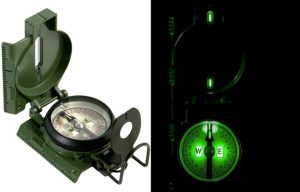
Now comes the “fun” part…the compass! Taking the guesswork out of it. There are many on the market, and JJ’s preference is the Tritium Lensatic Compass of the United States Army. You can do much with this piece of equipment. It will give your azimuth (direction based on the 360 degrees of a circle) for a direction of travel, as well as your cardinal N-S-E-W directions. The tritium is a radioactive element that allows the whole thing to glow in the dark without the introduction of light to “charge” it up.
The compass will run you $70.00 on Amazon.com, and it is by far the most dependable one there is. I have had mine for more than 20 years without any problems: the most common being “sticking” caused by severe impact numerous times. The best way to avoid this is to actually take care of the compass. Seems simple enough, but most people bang them up and do not keep them protected when not in use. It comes with a lanyard that can be looped through your equipment. Don’t hang it around your neck, as it is strong enough to garotte you if you fall and catch it on something.
Yes, there are a host of electronic gadgets by Suunto and Garmin, and all, but these work by battery, and some are GPS. What to do when an EMP strikes, or you run out of juice? But the lensatic compass will see you through, and point you in the right direction.
In the next part of the Series, we’ll cover the finer points of using that lensatic compass, from simple cardinal directions and variants to actual direction with the azimuth. We’ll cover declination (a must for you to know in your geographic locale), and some points on walking with the compass and use of it with a map. Until then, start gathering your reference materials from part one and your compass. Then we’ll plan our trekking! Until then, keep up the good fight! JJ out.
