“A soldier is never lost, he’s just temporarily disoriented.”
– An old Army saying
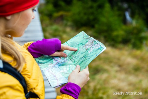
Well, ReadyNutrition Readers, you’re not lost, as you have found this site! Today we’re going to cover some of the finer points of land navigation. “Map reading” is an oversimplified term that does not cover the broader, more comprehensive category of land navigation, or “land nav,” as we referred to it in the service. It is very important skill to learn and takes time and practice to develop effectively. Let’s get started.
I recommend the older Army publication for a reference guide, the one I’m familiar with that I can recommend to you by experience: FM 21-26 Map Reading and Land Navigation. It gives you everything you need. The newer manual is FM 3-25.26 (entitled the same), and although I’m sure it is worthwhile, I don’t know it. I have to give you what I know, and what I know that works as your basis for land nav.
Learn to Pace Count
If you’re hiking across unimproved terrain, you need a pace count for yourself. I have been “brought up” with Uncle Sugar…the Army’s method…that is in meters, as all military maps are in kilometers and meters. Don’t worry: if you have one of the Army’s maps, it has a conversion scale to feet and miles. If you feel the need, stick with English units, but the meters are easier to add and adjust while you’re backpacking along. Now we’re going to show you how to figure out your pace count.
Start off by using a tape measure (the longer the better) to measure from a fixed point (point A), and measure off 100 meters, and mark that point (point B). Trees are excellent for this, and you can tie off a ribbon or string to A and B to always be able to use them. Start from point A, and take a comfortable walking step, and then another. These two steps constitute a pace. Left, right is one. Step with the left and count on the right, all the way up until you’ve reached point B. The number is your pace without any equipment. Mine happens to be 65.
How To Mark Meters
When you’re wearing a backpack, your pace count changes and is increased, because you have more weight to bear and you end up taking shorter steps. When I have my rucksack on, my count is 70. These numbers (unencumbered and encumbered) constitute your pace counts for each, respectively: you must memorize them!
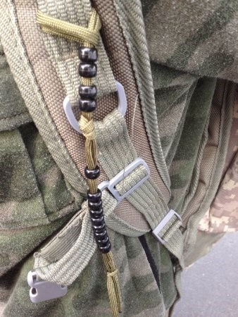
Now what? Well, once you have that, you then need to figure out a way to mark off your groups of 100 meters. Pace count beads are what I used in the service. It is nothing more than a string of 550 parachute cord with 9 sliding discs or beads, a knot, and another 4 sliding discs that terminate in a knot and the whole thing is tied off on your equipment (camelback, pocket, etc.). As you travel 100 meters, slip a disc down, and so on. When you’ve slid all of them down, then with your 10th hundred meters, slide one of the top four down and reset the bottom 9 back to their original position. The top measures kilometers, or “klicks” that constitute 1000 meters per “klick.” This distance equals 6/10 of a mile, for your conversion.
Therefore, if you travel 8 klicks, you have covered 4.8 miles. Simple enough, right? But it takes practice. Other adjustments you must make are with regard to terrain. The rougher the terrain, the more objects (stumps, large holes, rocks, etc.) you will have to bypass, and this will force you to adjust your pace count accordingly. Night, inclement weather, water features, and thick vegetation will take both considerable practice and additional adjustments to gauge the distance you have traveled. Bad guys add even more!
If you don’t prefer to use the military method, you can take that tape measure and figure out a pace count in feet. You can accomplish it by doing it in 100 foot increments, as it is then easier to add, but it will be time-consuming this way. I strongly recommend using the metric system for your pace count. You can easily convert to feet and after a while it becomes second nature where you won’t even have to write anything down and can do it mentally. Also, you can always use a civilian map and convert the miles easily to kilometers (divide miles by 2.2), and if you come across a military map? Oh, you’ll be doing good, because you’ll have the unit down…and military maps are very detailed. We’ll discuss them later.
Your pace count is your key to movement and land navigation on your feet. It is the basis for your two components of land navigation when traveling from one location to another: distance and direction. In the next part of the series we’re going to cover the direction component. Until then, happy pace-counting, and remember: practice makes perfect! JJ out!
Check out part 2 of this navigation series: Using the Stars to Navigate
This article was originally published at Ready Nutrition™ on July 2nd, 2016