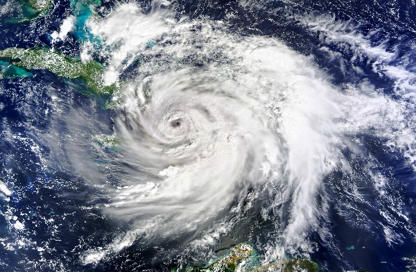
Hurricanes are getting worse and more severe. They’re bigger, wetter, stronger, and slower. Scientists agree that the 2022 Atlantic Ocean hurricane season, spanning June 1 to November 30, will be the seventh straight season with more storms than average.
Recent seasons have been marked by an increase in rapidly intensifying hurricanes linked to warming ocean waters. Because of this terrifying vision, researchers are planning a new state-of-the-art facility to re-create the havoc wreaked by the most powerful hurricanes on Earth. In January, the National Science Foundation awarded a $12.8 million grant to researchers to design a facility that can simulate wind speeds of at least 290 km/h — and can, at the same time, produce deadly, towering storm surges.
An Antiquated Scaling System
Scientists are suggesting the current scaling system used for categorizing hurricanes may be outdated. As the storms continue to worsen, scientists insist that those who live in coastal communities around the world need to know how to prepare: how to build structures — buildings, bridges, roads, water, and energy systems — that are resilient to such punishing winds and waves. That’s where simulating an intense storm comes into play.
More Hurricanes Are Incoming! Prepare For Them Now!
This will lead to an ability to potentially prepare for a category 6 hurricane. So far, category 5 is the highest, but as the storms worsen, we could see a category 6 on Earth. Here’s what a category 6 hurricane looks like and the damage it can create.
Are Category 6 Storms Even Possible?
To help with preparations for a category 6 storm, Florida International University in Miami researchers are leading a team of wind and structural engineers, coastal and ocean engineers, computational modelers, and resilience experts from around the United States to work out how best to simulate these types of devastating storms. Combining extreme wind and water surges into one facility is uncharted territory, says Ioannis Zisis, a wind engineer at FIU. “There is a need to push the envelope,” Zisis says. But as for how exactly to do it, “the answer is simple: We don’t know. That’s what we want to find out.”
Even though category 6 hurricanes are not official designations, storms of intense magnitude have been referred to as such. Just in the last few years, Hurricanes Dorian (2019) and Irma (2017) in the Atlantic Ocean and super Typhoon Haiyan (2013) in the Pacific Ocean have brought storms with wind speeds well over 290 km/h.
But it isn’t just wind speed that needs to be taken into account. According to the video above, scientists question whether or not to add additional factors such as total rainfall and even damage to landmasses to determine how catastrophic a hurricane can be.
Get prepared for any disaster with this FREE family-based preparedness guide
How Hurricanes are Categorized
The National Oceanic and Atmospheric Administration, or NOAA, rates hurricanes in the Atlantic and eastern Pacific oceans on a scale of 1 to 5, based on their wind speeds and how much damage those winds might do. Each category spans an increment of roughly 30 km/h.
Category 1 hurricanes, with wind speeds of 119 to 153 km/h, produce “some damage,” bringing down some power lines, toppling trees and perhaps knocking roof shingles or vinyl siding off a house. Category 5 storms, with winds starting at 252 km/h, cause “catastrophic damage,” bulldozing buildings and potentially leaving neighborhoods uninhabitable for weeks to months.
But 5 is as high as it gets on the official scale; after all, what could be more devastating than catastrophic damage? That means that even monster storms like 2019’s Hurricane Dorian, which flattened the Bahamas with wind speeds of up to nearly 300 km/h, are still considered category 5. -Science News
FIU already hosts the Wall of Wind, a massive hurricane simulator located in a large hangar anchored at one end by an arc of 12 massive yellow fans. Even at low wind speeds (around 50 km/h), the fans generate a loud, unsettling hum. At full blast, those fans can generate wind speeds of up to 252 km/h which is equivalent to a low-grade category 5 hurricane.
If the scientists are successful at creating a category 6 hurricane, then they could help people prepare for what is coming.
Additional Reading:
Essential Hurricane Preparedness Skills You Need to Know Before the Next Storm Arrives
12 Tips To Prepare Your Property for Hurricane Season
6 Critical Items That Have Disappeared in the Immediate Aftermath of Hurricane Harvey
20 Hurricane Survival Tips From Real-Life Scenarios
Hurricane Preparation: How to Board Up Your Windows Like a Pro
This article was originally published at Ready Nutrition™ on June 8th, 2022


Hopefully a Category 7 will slam into the east coast in the DC area and maintain its strength and destruction along the coast until Maine. 100 miles inland from the coastline totally wiped off the planet.
“As the storms continue to worsen”
Bullcrap. Storms aren’t worsening. Storm intensity waxes and wanes with the season. In addition, maybe people shouldn’t build in hurricane-prone areas. You know why we have “more storms” recently? Because NOAA counts even depressions that don’t turn into anything as a “storm.”
Also, global warming/climate change is a fraud. Nothing more than a leftist money grab. Take a damned meteorology course or two.